Make a donation
Gear up for your next adventure:
As an Amazon Associate, this site earns from qualifying purchases at no extra cost to you.
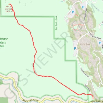
Mount Morrison Trail in Matthews/Winters Park
The Mount Morrison Trail offers a rigorous climb through scenic terrain, providing hikers with expansive views of the surrounding Colorado landscape, including the iconic Red Rocks formations, the distant cityscape of Denver, and the rugged peaks of the Front Range. As you ascend, the trail showcases dramatic red sandstone rock features, remnants of the ancient Fountain Formation, and panoramic vistas of the Rocky Mountains. Although challenging, the trail rewards trekkers with breathtaking perspectives from the summit, making it a worthwhile hike for those seeking both natural beauty and a physical challenge. #Hiking #Mountain #Nature #Overlook
- Distance: 3.6 mi
- Elevation gain: 2,051 ft
- Maximum elevation: 7,851 ft
- Elevation loss: 2,051 ft
- Minimum elevation: 5,892 ft
- Moving time: 2 h 36 m
- Moving speed: 1.4 mph
- Maximum speed: 3.1 mph
- Total time: 3 h 56 m
- Global speed: 0.9 mph
Interactive trail map
Make a donation
Gear up for your next adventure:
As an Amazon Associate, this site earns from qualifying purchases at no extra cost to you.
Trail profile
- Distance: 3.6 mi
- Elevation gain: 2,051 ft
- Maximum elevation: 7,851 ft
- Elevation loss: 2,051 ft
- Minimum elevation: 5,892 ft
- Moving time: 2 h 36 m
- Moving speed: 1.4 mph
- Maximum speed: 3.1 mph
- Total time: 3 h 56 m
- Global speed: 0.9 mph
Make a donation
Gear up for your next adventure:
As an Amazon Associate, this site earns from qualifying purchases at no extra cost to you.
About this trail
Name: Mount Morrison Trail in Matthews/Winters Park trail, distance, elevation, map, profile, GPS track
Start: Titans Road, Jefferson County, Colorado, 80465, United States (39.65364 -105.20211)
End: Titans Road, Jefferson County, Colorado, 80465, United States (39.65363 -105.20212)
Coordinates: 39.65363 -105.21977 39.66922 -105.20208
Topography: Jefferson County topographic map, elevation, terrain
Make a donation
Gear up for your next adventure:
As an Amazon Associate, this site earns from qualifying purchases at no extra cost to you.
Other hiking, mountain biking, running and outdoor activity trails
Click on a trail to view its statistics, map and profile.
Trading Post Trail in Red Rocks Park
United States > Colorado > Jefferson County
The Trading Post Trail in Red Rocks Park is a delightful loop that showcases the park's breathtaking red rock formations and offers sweeping views of the surrounding landscapes. As you meander along this well-maintained path, you’ll encounter several sets of stairs that add a fun challenge, all while being…
Distance: 1.6 mi • Elevation gain: 361 ft • Maximum elevation: 6,276 ft