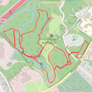
Frelinghuysen Arboretum
- Distance: 3.0 mi
- Elevation gain: 240 ft
- Maximum elevation: 404 ft
- Elevation loss: 256 ft
- Minimum elevation: 269 ft
- Moving time: 56 m 54 s
- Moving speed: 3.1 mph
- Maximum speed: 6.1 mph
- Total time: 1 h 3 m
- Global speed: 2.8 mph
Interactive trail map
Trail profile
- Distance: 3.0 mi
- Elevation gain: 240 ft
- Maximum elevation: 404 ft
- Elevation loss: 256 ft
- Minimum elevation: 269 ft
- Moving time: 56 m 54 s
- Moving speed: 3.1 mph
- Maximum speed: 6.1 mph
- Total time: 1 h 3 m
- Global speed: 2.8 mph
About this trail
Name: Frelinghuysen Arboretum trail, distance, elevation, map, profile, GPS track
Start: Whippany Road, Morris Township, Morris County, New Jersey, 07960, United States (40.80184 -74.45132)
Coordinates: 40.79899 -74.45808 40.80479 -74.44919
Topography: Morris Township topographic map, elevation, terrain