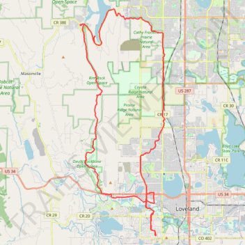
Devils Backbone up to Horsetooth Mountain and back
- Distance: 34.7 mi
- Elevation gain: 2,247 ft
- Maximum elevation: 5,728 ft
- Elevation loss: 2,247 ft
- Minimum elevation: 4,977 ft
- Moving time: 4 h 40 m
- Moving speed: 7.4 mph
- Maximum speed: 27.4 mph
- Total time: 6 h 48 m
- Global speed: 5.1 mph
Interactive trail map
Trail profile
- Distance: 34.7 mi
- Elevation gain: 2,247 ft
- Maximum elevation: 5,728 ft
- Elevation loss: 2,247 ft
- Minimum elevation: 4,977 ft
- Moving time: 4 h 40 m
- Moving speed: 7.4 mph
- Maximum speed: 27.4 mph
- Total time: 6 h 48 m
- Global speed: 5.1 mph
About this trail
Name: Devils Backbone up to Horsetooth Mountain and back trail, distance, elevation, map, profile, GPS track
Start: 1241, Heather Drive, Loveland, Larimer County, Colorado, 80537, United States (40.37969 -105.10257)
End: 1243, Heather Drive, Loveland, Larimer County, Colorado, 80537, United States (40.37973 -105.10254)
Coordinates: 40.37969 -105.16800 40.52873 -105.09421
Topography: Loveland topographic map, elevation, terrain
Other hiking, mountain biking, running and outdoor activity trails
Click on a trail to view its statistics, map and profile.
Poudre River trail
United States > Colorado > Larimer County > Fort Collins
Fort Collins Cycling
Distance: 29.0 mi • Elevation gain: 620 ft • Maximum elevation: 5,108 ft