Palmer State Park Loop Trails
- Distance: 3.3 mi
- Elevation gain: 387 ft
- Maximum elevation: 459 ft
- Elevation loss: 387 ft
- Minimum elevation: 157 ft
- Moving time: 1 h 23 m
- Moving speed: 2.3 mph
- Maximum speed: 3.8 mph
- Total time: 1 h 36 m
- Global speed: 2.0 mph
Interactive trail map
Trail profile
- Distance: 3.3 mi
- Elevation gain: 387 ft
- Maximum elevation: 459 ft
- Elevation loss: 387 ft
- Minimum elevation: 157 ft
- Moving time: 1 h 23 m
- Moving speed: 2.3 mph
- Maximum speed: 3.8 mph
- Total time: 1 h 36 m
- Global speed: 2.0 mph
About this trail
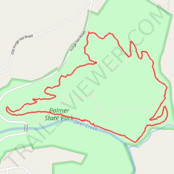
Name: Palmer State Park Loop Trails trail, distance, elevation, map, profile, GPS track
Coordinates: 39.61319 -76.28620 39.62172 -76.27003
Topography: Harford County topographic map, elevation, terrain