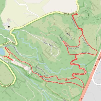
Thimbleberry Trail, Bear Creek Redwoods, CA
- Distance: 3.1 mi
- Elevation gain: 466 ft
- Maximum elevation: 984 ft
- Elevation loss: 400 ft
- Minimum elevation: 741 ft
- Moving time: 1 h 18 m
- Moving speed: 2.3 mph
- Maximum speed: 11.2 mph
- Total time: 1 h 28 m
- Global speed: 2.1 mph
Interactive trail map
Trail profile
- Distance: 3.1 mi
- Elevation gain: 466 ft
- Maximum elevation: 984 ft
- Elevation loss: 400 ft
- Minimum elevation: 741 ft
- Moving time: 1 h 18 m
- Moving speed: 2.3 mph
- Maximum speed: 11.2 mph
- Total time: 1 h 28 m
- Global speed: 2.1 mph
About this trail
Name: Thimbleberry Trail, Bear Creek Redwoods, CA trail, distance, elevation, map, profile, GPS track
Start: Salamander Springs Trail, Santa Clara County, California, 95030, United States (37.18123 -121.99969)
End: Upper Lake Loop Trail, Santa Clara County, California, 95030, United States (37.18298 -122.00402)
Coordinates: 37.18008 -122.00402 37.18712 -121.99303
Topography: Santa Clara County topographic map, elevation, terrain
Other hiking, mountain biking, running and outdoor activity trails
Click on a trail to view its statistics, map and profile.
Myotis and Toad Hollow Trails, Bear Creek Redwoods, CA
United States > California > Santa Clara County
Distance: 3.7 mi • Elevation gain: 538 ft • Maximum elevation: 994 ft
Lower Pete Siemens Trail, Bear Creek Redwoods, CA
United States > California > Santa Clara County
Distance: 3.4 mi • Elevation gain: 420 ft • Maximum elevation: 991 ft