Make a donation
Gear up for your next adventure:
As an Amazon Associate, this site earns from qualifying purchases at no extra cost to you.
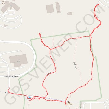
Walking at Walker & Robinson Memorial Reservation
- Distance: 1.4 mi
- Elevation gain: 108 ft
- Maximum elevation: 433 ft
- Elevation loss: 98 ft
- Minimum elevation: 358 ft
- Moving time: 35 m 36 s
- Moving speed: 2.3 mph
- Maximum speed: 5.8 mph
- Total time: 38 m 29 s
- Global speed: 2.1 mph
Interactive trail map
Make a donation
Gear up for your next adventure:
As an Amazon Associate, this site earns from qualifying purchases at no extra cost to you.
Trail profile
- Distance: 1.4 mi
- Elevation gain: 108 ft
- Maximum elevation: 433 ft
- Elevation loss: 98 ft
- Minimum elevation: 358 ft
- Moving time: 35 m 36 s
- Moving speed: 2.3 mph
- Maximum speed: 5.8 mph
- Total time: 38 m 29 s
- Global speed: 2.1 mph
Make a donation
Gear up for your next adventure:
As an Amazon Associate, this site earns from qualifying purchases at no extra cost to you.
About this trail
Name: Walking at Walker & Robinson Memorial Reservation trail, distance, elevation, map, profile, GPS track
End: Lower Loop, Westborough, Worcester County, Massachusetts, 01784, United States (42.27891 -71.57939)
Coordinates: 42.27869 -71.58082 42.28368 -71.57461
Topography: Worcester County topographic map, elevation, terrain
Make a donation
Gear up for your next adventure:
As an Amazon Associate, this site earns from qualifying purchases at no extra cost to you.
Other hiking, mountain biking, running and outdoor activity trails
Click on a trail to view its statistics, map and profile.
2024 Bikes Not Bombs Bike-a-thon (BAT) Agony & Ecstasy
United States > Massachusetts > Suffolk County > Boston
Distance: 106.4 mi • Elevation gain: 5,623 ft • Maximum elevation: 600 ft
Loop in Eastern Mass involving various rail trails
United States > Massachusetts > Middlesex County > Newton
Distance: 126.6 mi • Elevation gain: 6,365 ft • Maximum elevation: 636 ft