Make a donation
Gear up for your next adventure:
As an Amazon Associate, this site earns from qualifying purchases at no extra cost to you.
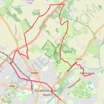
Trailrun Stratford-upon-Avon
Morning Run
- Distance: 8.7 mi
- Elevation gain: 459 ft
- Maximum elevation: 367 ft
- Elevation loss: 466 ft
- Minimum elevation: 118 ft
- Moving time: 1 h 22 m
- Moving speed: 6.3 mph
- Maximum speed: 10.3 mph
- Total time: 1 h 23 m
- Global speed: 6.2 mph
Interactive trail map
Make a donation
Gear up for your next adventure:
As an Amazon Associate, this site earns from qualifying purchases at no extra cost to you.
Trail profile
- Distance: 8.7 mi
- Elevation gain: 459 ft
- Maximum elevation: 367 ft
- Elevation loss: 466 ft
- Minimum elevation: 118 ft
- Moving time: 1 h 22 m
- Moving speed: 6.3 mph
- Maximum speed: 10.3 mph
- Total time: 1 h 23 m
- Global speed: 6.2 mph
Make a donation
Gear up for your next adventure:
As an Amazon Associate, this site earns from qualifying purchases at no extra cost to you.
About this trail
Name: Trailrun Stratford-upon-Avon trail, distance, elevation, map, profile, GPS track
Coordinates: 52.18972 -1.73099 52.22893 -1.67492
Make a donation
Gear up for your next adventure:
As an Amazon Associate, this site earns from qualifying purchases at no extra cost to you.
Other hiking, mountain biking, running and outdoor activity trails
Click on a trail to view its statistics, map and profile.
Trailrun to Snitterfield
United Kingdom > England > Warwickshire > Stratford-on-Avon > Stratford-upon-Avon > Lower Clopton
Distance: 6.1 mi • Elevation gain: 299 ft • Maximum elevation: 374 ft
River Avon Loop Walk
United Kingdom > England > Warwickshire > Stratford-on-Avon > Stratford-upon-Avon
Distance: 3.2 mi • Elevation gain: 56 ft • Maximum elevation: 141 ft