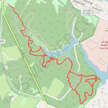
Wormley Pond East
York County MOUNTAIN
- Distance: 7.8 mi
- Elevation gain: 348 ft
- Maximum elevation: 69 ft
- Elevation loss: 348 ft
- Minimum elevation: 13 ft
- Moving time: 1 h 18 m
- Moving speed: 5.9 mph
- Maximum speed: 19.9 mph
- Total time: 1 h 20 m
- Global speed: 5.8 mph
Interactive trail map
Trail profile
- Distance: 7.8 mi
- Elevation gain: 348 ft
- Maximum elevation: 69 ft
- Elevation loss: 348 ft
- Minimum elevation: 13 ft
- Moving time: 1 h 18 m
- Moving speed: 5.9 mph
- Maximum speed: 19.9 mph
- Total time: 1 h 20 m
- Global speed: 5.8 mph
About this trail
Name: Wormley Pond East trail, distance, elevation, map, profile, GPS track
End: Cook Road, York County, Virginia, 23690, United States (37.22278 -76.50571)
Coordinates: 37.20711 -76.50571 37.22278 -76.48741
Topography: York County topographic map, elevation, terrain
Other hiking, mountain biking, running and outdoor activity trails
Click on a trail to view its statistics, map and profile.
Wormley Pond Trail
United States > Virginia > York County
York County MTB
Distance: 2.6 mi • Elevation gain: 102 ft • Maximum elevation: 72 ft
Wormley Pond
United States > Virginia > York County
York County MOUNTAIN
Distance: 4.3 mi • Elevation gain: 167 ft • Maximum elevation: 69 ft