Griffith Park
Loop hike in Griffith Park to abandoned mountaintop pool and nearby. #Hiking #Loop #Park #Nature #Forest #Mountain
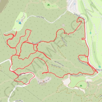
- Distance: 5.6 mi
- Elevation gain: 1,827 ft
- Maximum elevation: 1,181 ft
- Elevation loss: 1,827 ft
- Minimum elevation: 509 ft
- Moving time: 2 h 46 m
- Moving speed: 2.0 mph
- Maximum speed: 4.9 mph
- Total time: 3 h 17 m
- Global speed: 1.7 mph
Interactive trail map
Trail profile
- Distance: 5.6 mi
- Elevation gain: 1,827 ft
- Maximum elevation: 1,181 ft
- Elevation loss: 1,827 ft
- Minimum elevation: 509 ft
- Moving time: 2 h 46 m
- Moving speed: 2.0 mph
- Maximum speed: 4.9 mph
- Total time: 3 h 17 m
- Global speed: 1.7 mph
About this trail
Name: Griffith Park trail, distance, elevation, map, profile, GPS track
Coordinates: 34.13398 -118.29856 34.14118 -118.28646
Topography: Los Angeles topographic map, elevation, terrain
Other hiking, mountain biking, running and outdoor activity trails
Click on a trail to view its statistics, map and profile.
Tom LaBonge Panorama via Bill Eckert Trail and North Trail in Griffith Park
United States > California > Los Angeles County > Los Angeles
This trail to Tom LaBonge Panorama offers a moderately challenging hike in Griffith Park, winding through scenic vistas with views of Mount Hollywood, Taco Peak, and the iconic Hollywood Sign. The trail provides a rewarding panoramic perspective of Los Angeles, including landmarks like the Griffith Park Old…
Distance: 6.2 mi • Elevation gain: 1,512 ft • Maximum elevation: 1,568 ft