Thank you for supporting this site ❤️
Make a donation
Make a donation
Gear up for your next adventure:
As an Amazon Associate, this site earns from qualifying purchases at no extra cost to you.
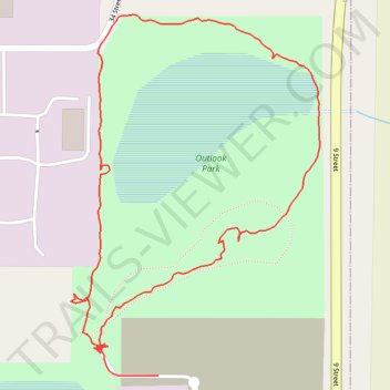
Outlook Park Loop
- Distance: 1.0 mi
- Elevation gain: 20 ft
- Maximum elevation: 2,395 ft
- Elevation loss: 20 ft
- Minimum elevation: 2,375 ft
- Moving time: 23 m 23 s
- Moving speed: 2.5 mph
- Maximum speed: 18.1 mph
- Total time: 32 m 8 s
- Global speed: 1.8 mph
Interactive trail map
Thank you for supporting this site ❤️
Make a donation
Make a donation
Gear up for your next adventure:
As an Amazon Associate, this site earns from qualifying purchases at no extra cost to you.
Trail profile
- Distance: 1.0 mi
- Elevation gain: 20 ft
- Maximum elevation: 2,395 ft
- Elevation loss: 20 ft
- Minimum elevation: 2,375 ft
- Moving time: 23 m 23 s
- Moving speed: 2.5 mph
- Maximum speed: 18.1 mph
- Total time: 32 m 8 s
- Global speed: 1.8 mph
Thank you for supporting this site ❤️
Make a donation
Make a donation
Gear up for your next adventure:
As an Amazon Associate, this site earns from qualifying purchases at no extra cost to you.
About this trail
Name: Outlook Park Loop trail, distance, elevation, map, profile, GPS track
Start: 33 Street, Leduc Business Park, City of Leduc, Alberta, T9E 0R8, Canada (53.29706 -113.51732)
End: 33 Street, Leduc Business Park, City of Leduc, Alberta, T9E 0R8, Canada (53.29671 -113.51634)
Coordinates: 53.29671 -113.51794 53.30064 -113.51341
Thank you for supporting this site ❤️
Make a donation
Make a donation
Gear up for your next adventure:
As an Amazon Associate, this site earns from qualifying purchases at no extra cost to you.