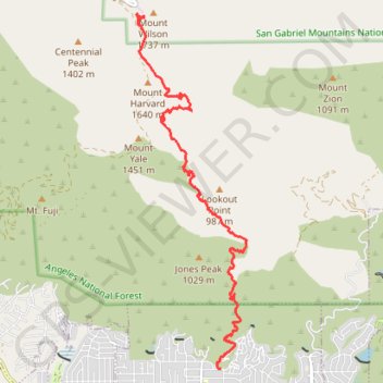
Mount Wilson
Hike to Mount Wilson from Sierra Madre via Mount Wilson Trail in Angeles National Forest. #Hiking #Mountain #Nature #Forest #Angeles
- Distance: 7.1 mi
- Elevation gain: 5,597 ft
- Maximum elevation: 5,640 ft
- Elevation loss: 948 ft
- Minimum elevation: 988 ft
- Moving time: 1 h 7 m
- Moving speed: 6.3 mph
- Maximum speed: 10.2 mph
- Total time: 1 h 7 m
- Global speed: 6.3 mph
Interactive trail map
Trail profile
- Distance: 7.1 mi
- Elevation gain: 5,597 ft
- Maximum elevation: 5,640 ft
- Elevation loss: 948 ft
- Minimum elevation: 988 ft
- Moving time: 1 h 7 m
- Moving speed: 6.3 mph
- Maximum speed: 10.2 mph
- Total time: 1 h 7 m
- Global speed: 6.3 mph
About this trail
Name: Mount Wilson trail, distance, elevation, map, profile, GPS track
End: Rim Trail, Mount Wilson, Los Angeles County, California, 91023, United States (34.22312 -118.06266)
Coordinates: 34.16945 -118.06428 34.22358 -118.04380
Topography: Los Angeles County topographic map, elevation, terrain
Other hiking, mountain biking, running and outdoor activity trails
Click on a trail to view its statistics, map and profile.
Gabrielino Trail
United States > California > Los Angeles County
Starting from Chantry Flat, the Gabrielino Trail slips from the shaded ridge above Big Santa Anita Canyon into a classic Angeles National Forest corridor of wooded slopes, creekside cabins and canyon-bottom shade. The route passes the lower canyon junctions, Cascade Picnic Area and Spruce Grove Trail Camp…
Distance: 27.6 mi • Elevation gain: 7,736 ft • Maximum elevation: 4,662 ft
Mount Wilson Trail in Angeles National Forest
United States > California > Los Angeles County > Sierra Madre
The Mount Wilson Trail in the Angeles National Forest offers hikers a challenging ascent through diverse ecosystems, including shaded woodlands and rugged canyons. Along the route, one can observe the historic ruins of Orchard Camp, a popular resort from the 1890s to the 1930s. Upon reaching the summit, hikers…
Distance: 14.3 mi • Elevation gain: 6,001 ft • Maximum elevation: 5,663 ft