Har Turan
Loop running from Rumana. #Running #Loop #Mountain #Nature #Forest #Countryside
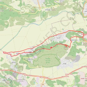
- Distance: 16.7 mi
- Elevation gain: 2,139 ft
- Maximum elevation: 1,778 ft
- Elevation loss: 2,139 ft
- Minimum elevation: 492 ft
- Moving time: 3 h 41 m
- Moving speed: 4.5 mph
- Maximum speed: 15.1 mph
- Total time: 3 h 41 m
- Global speed: 4.5 mph
Interactive trail map
Trail profile
- Distance: 16.7 mi
- Elevation gain: 2,139 ft
- Maximum elevation: 1,778 ft
- Elevation loss: 2,139 ft
- Minimum elevation: 492 ft
- Moving time: 3 h 41 m
- Moving speed: 4.5 mph
- Maximum speed: 15.1 mph
- Total time: 3 h 41 m
- Global speed: 4.5 mph
About this trail
Name: Har Turan trail, distance, elevation, map, profile, GPS track
Start: Al Batuf Regional Council, Jezreel Subdistrict, North District, 1710801, Israel (32.78771 35.31283)
End: Al Batuf Regional Council, Jezreel Subdistrict, North District, 1710801, Israel (32.78783 35.31306)
Coordinates: 32.78486 35.29242 32.81334 35.39794
Other hiking, mountain biking, running and outdoor activity trails
Click on a trail to view its statistics, map and profile.