Thank you for supporting this site ❤️
Make a donation
Make a donation
Gear up for your next adventure:
As an Amazon Associate, this site earns from qualifying purchases at no extra cost to you.
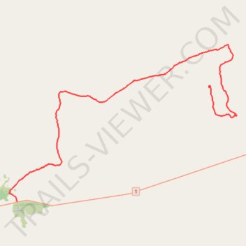
Track from Abrakurrie Cave to Mundrabilla
- Distance: 39.9 mi
- Elevation gain: 305 ft
- Maximum elevation: 358 ft
- Elevation loss: 568 ft
- Minimum elevation: 62 ft
- Moving time: 1 h 41 m
- Moving speed: 23.6 mph
- Maximum speed: 45.5 mph
- Total time: 1 h 54 m
- Global speed: 21.0 mph
Interactive trail map
Thank you for supporting this site ❤️
Make a donation
Make a donation
Gear up for your next adventure:
As an Amazon Associate, this site earns from qualifying purchases at no extra cost to you.
Trail profile
- Distance: 39.9 mi
- Elevation gain: 305 ft
- Maximum elevation: 358 ft
- Elevation loss: 568 ft
- Minimum elevation: 62 ft
- Moving time: 1 h 41 m
- Moving speed: 23.6 mph
- Maximum speed: 45.5 mph
- Total time: 1 h 54 m
- Global speed: 21.0 mph
Thank you for supporting this site ❤️
Make a donation
Make a donation
Gear up for your next adventure:
As an Amazon Associate, this site earns from qualifying purchases at no extra cost to you.
About this trail
Name: Track from Abrakurrie Cave to Mundrabilla trail, distance, elevation, map, profile, GPS track
Start: Kutowalla Doline, Eucla, Western Australia, 6443, Australia (-31.68224 128.49658)
Coordinates: -31.81754 128.21679 -31.63123 128.53427
Thank you for supporting this site ❤️
Make a donation
Make a donation
Gear up for your next adventure:
As an Amazon Associate, this site earns from qualifying purchases at no extra cost to you.