Make a donation
Gear up for your next adventure:
As an Amazon Associate, this site earns from qualifying purchases at no extra cost to you.
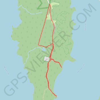
Paths on Mason Point Promontory
- Distance: 3.9 mi
- Elevation gain: 128 ft
- Maximum elevation: 282 ft
- Elevation loss: 125 ft
- Minimum elevation: 226 ft
- Moving time: 1 h 30 m
- Moving speed: 2.6 mph
- Maximum speed: 4.1 mph
- Total time: 1 h 56 m
- Global speed: 2.0 mph
Interactive trail map
Make a donation
Gear up for your next adventure:
As an Amazon Associate, this site earns from qualifying purchases at no extra cost to you.
Trail profile
- Distance: 3.9 mi
- Elevation gain: 128 ft
- Maximum elevation: 282 ft
- Elevation loss: 125 ft
- Minimum elevation: 226 ft
- Moving time: 1 h 30 m
- Moving speed: 2.6 mph
- Maximum speed: 4.1 mph
- Total time: 1 h 56 m
- Global speed: 2.0 mph
Make a donation
Gear up for your next adventure:
As an Amazon Associate, this site earns from qualifying purchases at no extra cost to you.
About this trail
Name: Paths on Mason Point Promontory trail, distance, elevation, map, profile, GPS track
Start: Transis Camp Road, Chatham County, North Carolina, United States (35.84127 -78.98724)
End: 2798, Transis Camp Road, Chatham County, North Carolina, 27713, United States (35.84126 -78.98731)
Coordinates: 35.82047 -78.99038 35.84127 -78.98384
Topography: Chatham County topographic map, elevation, terrain
Make a donation
Gear up for your next adventure:
As an Amazon Associate, this site earns from qualifying purchases at no extra cost to you.