Make a donation
Gear up for your next adventure:
As an Amazon Associate, this site earns from qualifying purchases at no extra cost to you.
Hillwalk Skiddaw
Hillwalk, Skiddaw
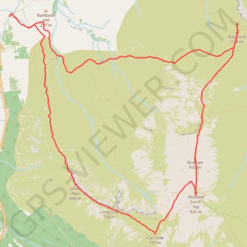
- Distance: 7.6 mi
- Elevation gain: 2,890 ft
- Maximum elevation: 3,025 ft
- Elevation loss: 2,890 ft
- Minimum elevation: 502 ft
- Moving time: 4 h 12 m
- Moving speed: 1.8 mph
- Maximum speed: 3.8 mph
- Total time: 4 h 33 m
- Global speed: 1.7 mph
Interactive trail map
Make a donation
Gear up for your next adventure:
As an Amazon Associate, this site earns from qualifying purchases at no extra cost to you.
Trail profile
- Distance: 7.6 mi
- Elevation gain: 2,890 ft
- Maximum elevation: 3,025 ft
- Elevation loss: 2,890 ft
- Minimum elevation: 502 ft
- Moving time: 4 h 12 m
- Moving speed: 1.8 mph
- Maximum speed: 3.8 mph
- Total time: 4 h 33 m
- Global speed: 1.7 mph
Make a donation
Gear up for your next adventure:
As an Amazon Associate, this site earns from qualifying purchases at no extra cost to you.
About this trail
Name: Hillwalk Skiddaw trail, distance, elevation, map, profile, GPS track
Start: High Side, Bassenthwaite, Cumberland, England, CA12 4QG, United Kingdom (54.66821 -3.18602)
End: High Side, Bassenthwaite, Cumberland, England, CA12 4QG, United Kingdom (54.66824 -3.18600)
Coordinates: 54.64236 -3.18608 54.66853 -3.13892
Make a donation
Gear up for your next adventure:
As an Amazon Associate, this site earns from qualifying purchases at no extra cost to you.
Other hiking, mountain biking, running and outdoor activity trails
Click on a trail to view its statistics, map and profile.
Blencathra, Knott and Skiddaw loop
United Kingdom > England > Cumberland > Keswick
Distance: 48.3 mi • Elevation gain: 14,311 ft • Maximum elevation: 3,025 ft