Thank you for supporting this site ❤️
Make a donation
Make a donation
Gear up for your next adventure:
As an Amazon Associate, this site earns from qualifying purchases at no extra cost to you.
Green field park
- Distance: 1.9 mi
- Elevation gain: 69 ft
- Maximum elevation: 387 ft
- Elevation loss: 69 ft
- Minimum elevation: 341 ft
- Moving time: 58 m 43 s
- Moving speed: 2.0 mph
- Maximum speed: 4.2 mph
- Total time: 1 h 1 m
- Global speed: 1.9 mph
Interactive trail map
Thank you for supporting this site ❤️
Make a donation
Make a donation
Gear up for your next adventure:
As an Amazon Associate, this site earns from qualifying purchases at no extra cost to you.
Trail profile
- Distance: 1.9 mi
- Elevation gain: 69 ft
- Maximum elevation: 387 ft
- Elevation loss: 69 ft
- Minimum elevation: 341 ft
- Moving time: 58 m 43 s
- Moving speed: 2.0 mph
- Maximum speed: 4.2 mph
- Total time: 1 h 1 m
- Global speed: 1.9 mph
Thank you for supporting this site ❤️
Make a donation
Make a donation
Gear up for your next adventure:
As an Amazon Associate, this site earns from qualifying purchases at no extra cost to you.
About this trail
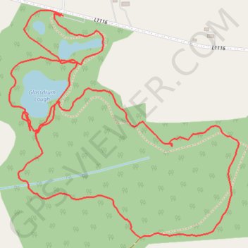
Name: Green field park trail, distance, elevation, map, profile, GPS track
Coordinates: 52.56707 -8.15446 52.57234 -8.14571
Thank you for supporting this site ❤️
Make a donation
Make a donation
Gear up for your next adventure:
As an Amazon Associate, this site earns from qualifying purchases at no extra cost to you.
Other hiking, mountain biking, running and outdoor activity trails
Click on a trail to view its statistics, map and profile.
Thurles - Cork
Ireland > County Tipperary > Thurles
#Bike
Distance: 80.6 mi • Elevation gain: 3,730 ft • Maximum elevation: 778 ft