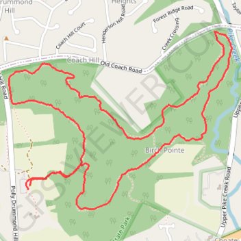
Chestnut Hill Loop Trail in White Clay Creek State Park
The Chestnut Hill Loop Trail offers a scenic mix of forested paths, rolling hills, and streamside views that make it a popular spot for nature lovers. The trail weaves through lush woodlands with patches of wildflowers and occasional footbridges over creeks, providing picturesque moments at almost every turn. It’s a peaceful, moderately challenging loop that offers the quiet beauty of Delaware’s landscapes year-round, especially during fall foliage season when the colors add a vibrant touch to the forested views. #Hiking #Loop #Forest #Nature
- Distance: 3.6 mi
- Elevation gain: 256 ft
- Maximum elevation: 253 ft
- Elevation loss: 259 ft
- Minimum elevation: 92 ft
- Moving time: 46 m 9 s
- Moving speed: 4.7 mph
- Maximum speed: 7.7 mph
- Total time: 46 m 9 s
- Global speed: 4.7 mph
Interactive trail map
Trail profile
- Distance: 3.6 mi
- Elevation gain: 256 ft
- Maximum elevation: 253 ft
- Elevation loss: 259 ft
- Minimum elevation: 92 ft
- Moving time: 46 m 9 s
- Moving speed: 4.7 mph
- Maximum speed: 7.7 mph
- Total time: 46 m 9 s
- Global speed: 4.7 mph
About this trail
Name: Chestnut Hill Loop Trail in White Clay Creek State Park trail, distance, elevation, map, profile, GPS track
Coordinates: 39.70394 -75.71024 39.71325 -75.69508
Topography: New Castle County topographic map, elevation, terrain