Thank you for supporting this site ❤️
Make a donation
Make a donation
Gear up for your next adventure:
As an Amazon Associate, this site earns from qualifying purchases at no extra cost to you.
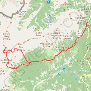
Julijski Alpi: od prevoja Vršić, Jalovška škrbina, Vratca v ...
- Distance: 11.2 mi
- Elevation gain: 6,824 ft
- Maximum elevation: 8,524 ft
- Elevation loss: 6,811 ft
- Minimum elevation: 4,793 ft
- Moving time: 8 h 24 m
- Moving speed: 1.3 mph
- Maximum speed: 3.1 mph
- Total time: 12 h 6 m
- Global speed: 0.9 mph
Interactive trail map
Thank you for supporting this site ❤️
Make a donation
Make a donation
Gear up for your next adventure:
As an Amazon Associate, this site earns from qualifying purchases at no extra cost to you.
Trail profile
- Distance: 11.2 mi
- Elevation gain: 6,824 ft
- Maximum elevation: 8,524 ft
- Elevation loss: 6,811 ft
- Minimum elevation: 4,793 ft
- Moving time: 8 h 24 m
- Moving speed: 1.3 mph
- Maximum speed: 3.1 mph
- Total time: 12 h 6 m
- Global speed: 0.9 mph
Thank you for supporting this site ❤️
Make a donation
Make a donation
Gear up for your next adventure:
As an Amazon Associate, this site earns from qualifying purchases at no extra cost to you.
About this trail
Name: Julijski Alpi: od prevoja Vršić, Jalovška škrbina, Vratca v ... trail, distance, elevation, map, profile, GPS track
Start: Vršiška cesta (Ruska cesta), Bovec, Slovenia (46.43503 13.74413)
End: Vršiška cesta (Ruska cesta), Bovec, Slovenia (46.43499 13.74428)
Coordinates: 46.40985 13.67803 46.43507 13.74428
Thank you for supporting this site ❤️
Make a donation
Make a donation
Gear up for your next adventure:
As an Amazon Associate, this site earns from qualifying purchases at no extra cost to you.