Make a donation
Gear up for your next adventure:
As an Amazon Associate, this site earns from qualifying purchases at no extra cost to you.
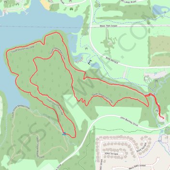
South Shore East Loop in Shawnee Mission Park
The South Shore East Loop is a delightful trail that offers a serene hiking experience surrounded by lush trees and scenic views of the lake. As you traverse the loop, you can expect to encounter a variety of wildlife and picturesque landscapes, making it an excellent choice for nature lovers and those seeking a peaceful outdoor escape. #Hiking #Loop #Lake #Forest #Nature
- Distance: 3.2 mi
- Elevation gain: 200 ft
- Maximum elevation: 971 ft
- Elevation loss: 197 ft
- Minimum elevation: 879 ft
- Moving time: 1 h 27 m
- Moving speed: 2.2 mph
- Maximum speed: 3.4 mph
- Total time: 1 h 32 m
- Global speed: 2.1 mph
Interactive trail map
Make a donation
Gear up for your next adventure:
As an Amazon Associate, this site earns from qualifying purchases at no extra cost to you.
Trail profile
- Distance: 3.2 mi
- Elevation gain: 200 ft
- Maximum elevation: 971 ft
- Elevation loss: 197 ft
- Minimum elevation: 879 ft
- Moving time: 1 h 27 m
- Moving speed: 2.2 mph
- Maximum speed: 3.4 mph
- Total time: 1 h 32 m
- Global speed: 2.1 mph
Make a donation
Gear up for your next adventure:
As an Amazon Associate, this site earns from qualifying purchases at no extra cost to you.
About this trail
Name: South Shore East Loop in Shawnee Mission Park trail, distance, elevation, map, profile, GPS track
Coordinates: 38.97798 -94.80114 38.98499 -94.78770
Topography: Lenexa topographic map, elevation, terrain
Make a donation
Gear up for your next adventure:
As an Amazon Associate, this site earns from qualifying purchases at no extra cost to you.