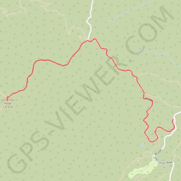
Los Pinos Peak
Interactive trail map
Trail profile
- Distance: 2.7 mi
- Elevation gain: 1,293 ft
- Maximum elevation: 4,462 ft
- Elevation loss: 249 ft
- Minimum elevation: 3,396 ft
About this trail
Name: Los Pinos Peak trail, distance, elevation, map, profile, GPS track
Start: North Main Divide Road, Orange County, California, 90000, United States (33.66215 -117.44802)
End: Los Pinos Trail, Orange County, California, 90000, United States (33.66427 -117.47158)
Coordinates: 33.65942 -117.47168 33.67160 -117.44789
Topography: Orange County topographic map, elevation, terrain