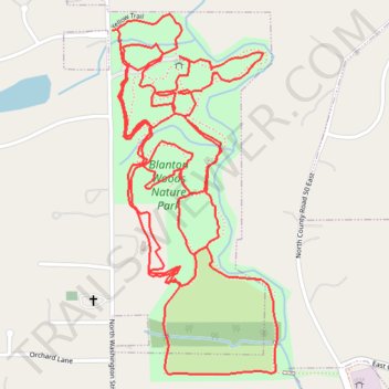
Hike of all trails in Blanton Woods
- Distance: 4.0 mi
- Elevation gain: 203 ft
- Maximum elevation: 909 ft
- Elevation loss: 203 ft
- Minimum elevation: 850 ft
- Moving time: 1 h 35 m
- Moving speed: 2.5 mph
- Maximum speed: 4.6 mph
- Total time: 1 h 38 m
- Global speed: 2.4 mph
Interactive trail map
Trail profile
- Distance: 4.0 mi
- Elevation gain: 203 ft
- Maximum elevation: 909 ft
- Elevation loss: 203 ft
- Minimum elevation: 850 ft
- Moving time: 1 h 35 m
- Moving speed: 2.5 mph
- Maximum speed: 4.6 mph
- Total time: 1 h 38 m
- Global speed: 2.4 mph
About this trail
Name: Hike of all trails in Blanton Woods trail, distance, elevation, map, profile, GPS track
Coordinates: 39.76780 -86.52391 39.77557 -86.51926
Topography: Hendricks County topographic map, elevation, terrain