Tarboro Indian Lake Park Loop Hike
- Distance: 3.6 mi
- Elevation gain: 52 ft
- Maximum elevation: 85 ft
- Elevation loss: 52 ft
- Minimum elevation: 69 ft
- Moving time: 1 h 19 m
- Moving speed: 2.7 mph
- Maximum speed: 4.0 mph
- Total time: 1 h 24 m
- Global speed: 2.5 mph
Interactive trail map
Trail profile
- Distance: 3.6 mi
- Elevation gain: 52 ft
- Maximum elevation: 85 ft
- Elevation loss: 52 ft
- Minimum elevation: 69 ft
- Moving time: 1 h 19 m
- Moving speed: 2.7 mph
- Maximum speed: 4.0 mph
- Total time: 1 h 24 m
- Global speed: 2.5 mph
About this trail
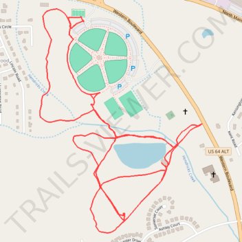
Name: Tarboro Indian Lake Park Loop Hike trail, distance, elevation, map, profile, GPS track
Coordinates: 35.91670 -77.57296 35.92622 -77.56443
Topography: Edgecombe County topographic map, elevation, terrain