Patiška Reka-Milenkov kamen-Mirska voda-Patiska reka
- Distance: 9.1 mi
- Elevation gain: 4,403 ft
- Maximum elevation: 7,224 ft
- Elevation loss: 4,393 ft
- Minimum elevation: 3,130 ft
- Moving time: 5 h 37 m
- Moving speed: 1.6 mph
- Maximum speed: 4.0 mph
- Total time: 8 h 10 m
- Global speed: 1.1 mph
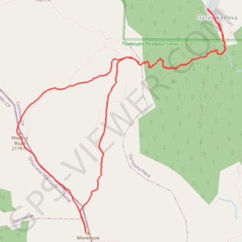
Interactive trail map
Trail profile
- Distance: 9.1 mi
- Elevation gain: 4,403 ft
- Maximum elevation: 7,224 ft
- Elevation loss: 4,393 ft
- Minimum elevation: 3,130 ft
- Moving time: 5 h 37 m
- Moving speed: 1.6 mph
- Maximum speed: 4.0 mph
- Total time: 8 h 10 m
- Global speed: 1.1 mph
About this trail
Name: Patiška Reka-Milenkov kamen-Mirska voda-Patiska reka trail, distance, elevation, map, profile, GPS track
Start: Patiška Reka, Patishka Reka, Municipality of Sopishte, North Macedonia (41.80048 21.31585)
End: Patiška Reka, Patishka Reka, Municipality of Sopishte, North Macedonia (41.80060 21.31571)
Coordinates: 41.76868 21.27925 41.80060 21.31926
Other hiking, mountain biking, running and outdoor activity trails
Click on a trail to view its statistics, map and profile.
Milenkov Kamen (Karadzica)
North Macedonia > Patishka Reka
Distance: 6.5 mi • Elevation gain: 3,360 ft • Maximum elevation: 7,218 ft