Thank you for supporting this site ❤️
Make a donation
Make a donation
Gear up for your next adventure:
As an Amazon Associate, this site earns from qualifying purchases at no extra cost to you.
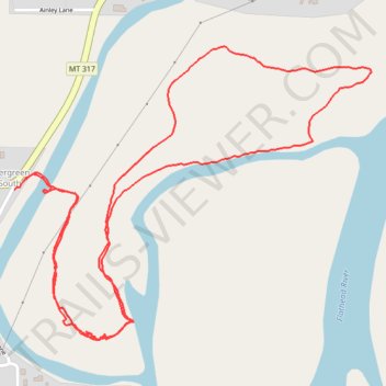
Flathead River Access
- Distance: 2.3 mi
- Elevation gain: 43 ft
- Maximum elevation: 2,923 ft
- Elevation loss: 43 ft
- Minimum elevation: 2,907 ft
- Moving time: 45 m 12 s
- Moving speed: 3.0 mph
- Maximum speed: 7.5 mph
- Total time: 47 m 6 s
- Global speed: 2.9 mph
Interactive trail map
Thank you for supporting this site ❤️
Make a donation
Make a donation
Gear up for your next adventure:
As an Amazon Associate, this site earns from qualifying purchases at no extra cost to you.
Trail profile
- Distance: 2.3 mi
- Elevation gain: 43 ft
- Maximum elevation: 2,923 ft
- Elevation loss: 43 ft
- Minimum elevation: 2,907 ft
- Moving time: 45 m 12 s
- Moving speed: 3.0 mph
- Maximum speed: 7.5 mph
- Total time: 47 m 6 s
- Global speed: 2.9 mph
Thank you for supporting this site ❤️
Make a donation
Make a donation
Gear up for your next adventure:
As an Amazon Associate, this site earns from qualifying purchases at no extra cost to you.
About this trail
Name: Flathead River Access trail, distance, elevation, map, profile, GPS track
Coordinates: 48.20104 -114.27725 48.20709 -114.26622
Topography: Flathead County topographic map, elevation, terrain
Thank you for supporting this site ❤️
Make a donation
Make a donation
Gear up for your next adventure:
As an Amazon Associate, this site earns from qualifying purchases at no extra cost to you.