Thank you for supporting this site ❤️
Make a donation
Make a donation
Gear up for your next adventure:
As an Amazon Associate, this site earns from qualifying purchases at no extra cost to you.
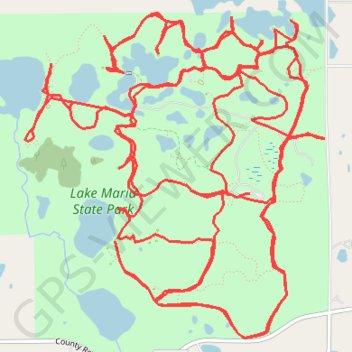
Lake Maria State Park
Wright County Running
- Distance: 20.3 mi
- Elevation gain: 951 ft
- Maximum elevation: 1,053 ft
- Elevation loss: 958 ft
- Minimum elevation: 965 ft
- Moving time: 6 h 56 s
- Moving speed: 3.4 mph
- Maximum speed: 8.8 mph
- Total time: 6 h 17 m
- Global speed: 3.2 mph
Interactive trail map
Thank you for supporting this site ❤️
Make a donation
Make a donation
Gear up for your next adventure:
As an Amazon Associate, this site earns from qualifying purchases at no extra cost to you.
Trail profile
- Distance: 20.3 mi
- Elevation gain: 951 ft
- Maximum elevation: 1,053 ft
- Elevation loss: 958 ft
- Minimum elevation: 965 ft
- Moving time: 6 h 56 s
- Moving speed: 3.4 mph
- Maximum speed: 8.8 mph
- Total time: 6 h 17 m
- Global speed: 3.2 mph
Thank you for supporting this site ❤️
Make a donation
Make a donation
Gear up for your next adventure:
As an Amazon Associate, this site earns from qualifying purchases at no extra cost to you.
About this trail
Name: Lake Maria State Park trail, distance, elevation, map, profile, GPS track
Coordinates: 45.30404 -93.96031 45.32580 -93.93165
Topography: Wright County topographic map, elevation, terrain
Thank you for supporting this site ❤️
Make a donation
Make a donation
Gear up for your next adventure:
As an Amazon Associate, this site earns from qualifying purchases at no extra cost to you.