Plympton paths
- Distance: 0.3 mi
- Elevation gain: 13 ft
- Maximum elevation: 46 ft
- Elevation loss: 20 ft
- Minimum elevation: 36 ft
- Moving time: 8 m 39 s
- Moving speed: 2.4 mph
- Maximum speed: 8.1 mph
- Total time: 8 m 39 s
- Global speed: 2.4 mph
Interactive trail map
Trail profile
- Distance: 0.3 mi
- Elevation gain: 13 ft
- Maximum elevation: 46 ft
- Elevation loss: 20 ft
- Minimum elevation: 36 ft
- Moving time: 8 m 39 s
- Moving speed: 2.4 mph
- Maximum speed: 8.1 mph
- Total time: 8 m 39 s
- Global speed: 2.4 mph
About this trail
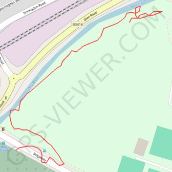
Name: Plympton paths trail, distance, elevation, map, profile, GPS track
Coordinates: 50.38905 -4.05885 50.39093 -4.05602