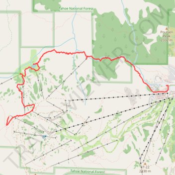
Shirley Lake trails
- Distance: 4.9 mi
- Elevation gain: 108 ft
- Maximum elevation: 8,724 ft
- Elevation loss: 2,615 ft
- Minimum elevation: 6,204 ft
- Moving time: 3 h 8 m
- Moving speed: 1.6 mph
- Maximum speed: 3.3 mph
- Total time: 5 h 18 m
- Global speed: 0.9 mph
Interactive trail map
Trail profile
- Distance: 4.9 mi
- Elevation gain: 108 ft
- Maximum elevation: 8,724 ft
- Elevation loss: 2,615 ft
- Minimum elevation: 6,204 ft
- Moving time: 3 h 8 m
- Moving speed: 1.6 mph
- Maximum speed: 3.3 mph
- Total time: 5 h 18 m
- Global speed: 0.9 mph
About this trail
Name: Shirley Lake trails trail, distance, elevation, map, profile, GPS track
Coordinates: 39.19044 -120.27696 39.20540 -120.23570
Topography: Placer County topographic map, elevation, terrain
Other hiking, mountain biking, running and outdoor activity trails
Click on a trail to view its statistics, map and profile.
Thunder Mountain Trail and Western States Trail Loop in Tahoe National Forest
United States > California > Placer County > Olympic Valley
Distance: 3.2 mi • Elevation gain: 833 ft • Maximum elevation: 6,955 ft
Shirley Canyon to Granite Chief trail
United States > California > Placer County > Olympic Valley
Distance: 10.0 mi • Elevation gain: 2,795 ft • Maximum elevation: 8,704 ft
Broken Arrow 23k
United States > California > Placer County > Olympic Valley
Distance: 11.8 mi • Elevation gain: 4,180 ft • Maximum elevation: 7,972 ft
Thunder Mountain Trail, Five Lakes Trail, Bear Creek Trail and Western States Trail Loop in Tahoe National Forest
United States > California > Placer County > Olympic Valley
Distance: 16.7 mi • Elevation gain: 3,865 ft • Maximum elevation: 7,726 ft
Broken Arrow 1-lapper
United States > California > Placer County > Olympic Valley
Distance: 14.5 mi • Elevation gain: 4,587 ft • Maximum elevation: 8,875 ft