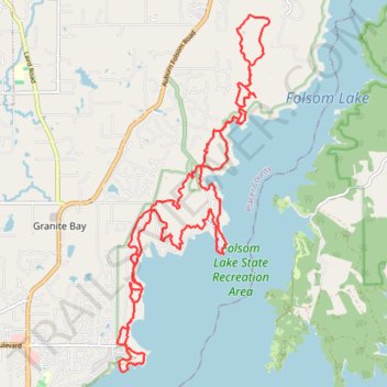
Long trail run in Folsom Lake State Recreation Area
- Distance: 17.7 mi
- Elevation gain: 1,519 ft
- Maximum elevation: 738 ft
- Elevation loss: 1,532 ft
- Minimum elevation: 453 ft
- Moving time: 4 h 23 m
- Moving speed: 4.0 mph
- Maximum speed: 11.5 mph
- Total time: 4 h 35 m
- Global speed: 3.9 mph
Interactive trail map
Trail profile
- Distance: 17.7 mi
- Elevation gain: 1,519 ft
- Maximum elevation: 738 ft
- Elevation loss: 1,532 ft
- Minimum elevation: 453 ft
- Moving time: 4 h 23 m
- Moving speed: 4.0 mph
- Maximum speed: 11.5 mph
- Total time: 4 h 35 m
- Global speed: 3.9 mph
About this trail
Name: Long trail run in Folsom Lake State Recreation Area trail, distance, elevation, map, profile, GPS track
Start: Park Road, Granite Bay, Placer County, California, United States (38.75055 -121.14780)
End: Park Road, Granite Bay, Placer County, California, United States (38.74761 -121.14839)
Coordinates: 38.73899 -121.15154 38.79812 -121.11920
Topography: Placer County topographic map, elevation, terrain