Thank you for supporting this site ❤️
Make a donation
Make a donation
Gear up for your next adventure:
As an Amazon Associate, this site earns from qualifying purchases at no extra cost to you.
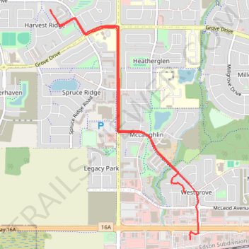
GoMap__2025_06_12__18_19_11
- Distance: 4.1 mi
- Elevation gain: 125 ft
- Maximum elevation: 2,320 ft
- Elevation loss: 118 ft
- Minimum elevation: 2,228 ft
Interactive trail map
Thank you for supporting this site ❤️
Make a donation
Make a donation
Gear up for your next adventure:
As an Amazon Associate, this site earns from qualifying purchases at no extra cost to you.
Trail profile
- Distance: 4.1 mi
- Elevation gain: 125 ft
- Maximum elevation: 2,320 ft
- Elevation loss: 118 ft
- Minimum elevation: 2,228 ft
Thank you for supporting this site ❤️
Make a donation
Make a donation
Gear up for your next adventure:
As an Amazon Associate, this site earns from qualifying purchases at no extra cost to you.
About this trail
Name: GoMap__2025_06_12__18_19_11 trail, distance, elevation, map, profile, GPS track
Coordinates: 53.54027 -113.94489 53.56092 -113.92250
Thank you for supporting this site ❤️
Make a donation
Make a donation
Gear up for your next adventure:
As an Amazon Associate, this site earns from qualifying purchases at no extra cost to you.