
Echidna Loop Trail
- Distance: 1.4 mi
- Elevation gain: 207 ft
- Maximum elevation: 600 ft
- Elevation loss: 207 ft
- Minimum elevation: 518 ft
- Moving time: 28 m 1 s
- Moving speed: 2.9 mph
- Maximum speed: 4.4 mph
- Total time: 29 m 51 s
- Global speed: 2.8 mph
Interactive trail map
Trail profile
- Distance: 1.4 mi
- Elevation gain: 207 ft
- Maximum elevation: 600 ft
- Elevation loss: 207 ft
- Minimum elevation: 518 ft
- Moving time: 28 m 1 s
- Moving speed: 2.9 mph
- Maximum speed: 4.4 mph
- Total time: 29 m 51 s
- Global speed: 2.8 mph
About this trail
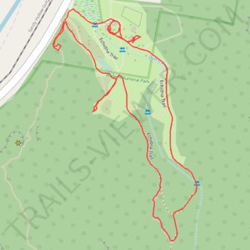
Name: Echidna Loop Trail trail, distance, elevation, map, profile, GPS track
Coordinates: -32.41789 150.33930 -32.41292 150.34296
Other hiking, mountain biking, running and outdoor activity trails
Click on a trail to view its statistics, map and profile.
Broadmeadow - Gulgong - Merrygoen - Dubbo railway
Australia > New South Wales > Newcastle
AU, NSW, railway
Distance: 232.6 mi • Elevation gain: 8,645 ft • Maximum elevation: 1,654 ft

Birthday Mountain Loop Trail and Echidna Trail
Australia > New South Wales > Stevens Flat
Afternoon Hike in Denman common
Distance: 3.1 mi • Elevation gain: 650 ft • Maximum elevation: 1,001 ft
Broadmeadow - Gulgong - Merrygoen - Dubbo railway
Australia > New South Wales > Newcastle
AU, NSW, railway
Distance: 233.2 mi • Elevation gain: 8,665 ft • Maximum elevation: 1,696 ft