Make a donation
Gear up for your next adventure:
As an Amazon Associate, this site earns from qualifying purchases at no extra cost to you.
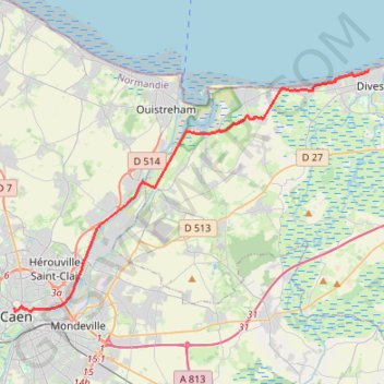
Caen Merville Cabourg (via Sallenelles)
- Distance: 16.1 mi
- Elevation gain: 367 ft
- Maximum elevation: 56 ft
- Elevation loss: 387 ft
- Minimum elevation: 0 ft
Interactive trail map
Make a donation
Gear up for your next adventure:
As an Amazon Associate, this site earns from qualifying purchases at no extra cost to you.
Trail profile
- Distance: 16.1 mi
- Elevation gain: 367 ft
- Maximum elevation: 56 ft
- Elevation loss: 387 ft
- Minimum elevation: 0 ft
Make a donation
Gear up for your next adventure:
As an Amazon Associate, this site earns from qualifying purchases at no extra cost to you.
About this trail
Name: Caen Merville Cabourg (via Sallenelles) trail, distance, elevation, map, profile, GPS track
Coordinates: 49.18299 -0.36470 49.29307 -0.11595
Make a donation
Gear up for your next adventure:
As an Amazon Associate, this site earns from qualifying purchases at no extra cost to you.
Other hiking, mountain biking, running and outdoor activity trails
Click on a trail to view its statistics, map and profile.
Bayeux-Caen short
France > Normandy > Calvados > Bayeux
Distance: 32.5 mi • Elevation gain: 1,329 ft • Maximum elevation: 253 ft
Bayeux-Caen Long
France > Normandy > Calvados > Bayeux
Distance: 39.9 mi • Elevation gain: 1,503 ft • Maximum elevation: 253 ft
Caen Beuvron Cabourg
France > Normandy > Calvados > Caen
Distance: 33.7 mi • Elevation gain: 1,217 ft • Maximum elevation: 190 ft
Caen Merville Cabourg
France > Normandy > Calvados > Caen
Distance: 16.9 mi • Elevation gain: 453 ft • Maximum elevation: 190 ft
Make a donation
Gear up for your next adventure:
As an Amazon Associate, this site earns from qualifying purchases at no extra cost to you.