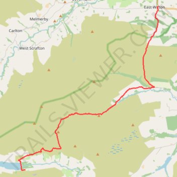
Hike from Scar House to East Witton
- Distance: 10.7 mi
- Elevation gain: 1,362 ft
- Maximum elevation: 1,598 ft
- Elevation loss: 2,005 ft
- Minimum elevation: 433 ft
- Moving time: 3 h 47 m
- Moving speed: 2.8 mph
- Maximum speed: 4.5 mph
- Total time: 3 h 53 m
- Global speed: 2.8 mph
Interactive trail map
Trail profile
- Distance: 10.7 mi
- Elevation gain: 1,362 ft
- Maximum elevation: 1,598 ft
- Elevation loss: 2,005 ft
- Minimum elevation: 433 ft
- Moving time: 3 h 47 m
- Moving speed: 2.8 mph
- Maximum speed: 4.5 mph
- Total time: 3 h 53 m
- Global speed: 2.8 mph
About this trail
Name: Hike from Scar House to East Witton trail, distance, elevation, map, profile, GPS track
Coordinates: 54.18553 -1.90148 54.26956 -1.77860
Other hiking, mountain biking, running and outdoor activity trails
Click on a trail to view its statistics, map and profile.
Hike from Scar House Reservoir to West Burton
United Kingdom > England > North Yorkshire
Walking @ North Yorkshire
Distance: 11.3 mi • Elevation gain: 1,562 ft • Maximum elevation: 1,594 ft