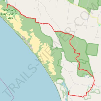
Great Southern West Walk - Swan Lake to Tarragal Caves
- Distance: 17.5 mi
- Elevation gain: 1,306 ft
- Maximum elevation: 709 ft
- Elevation loss: 1,286 ft
- Minimum elevation: 23 ft
- Moving time: 6 h 24 m
- Moving speed: 2.7 mph
- Maximum speed: 5.6 mph
- Total time: 6 h 52 m
- Global speed: 2.5 mph
Interactive trail map
Trail profile
- Distance: 17.5 mi
- Elevation gain: 1,306 ft
- Maximum elevation: 709 ft
- Elevation loss: 1,286 ft
- Minimum elevation: 23 ft
- Moving time: 6 h 24 m
- Moving speed: 2.7 mph
- Maximum speed: 5.6 mph
- Total time: 6 h 52 m
- Global speed: 2.5 mph
About this trail
Name: Great Southern West Walk - Swan Lake to Tarragal Caves trail, distance, elevation, map, profile, GPS track
Start: Swan Lake Road, Mount Richmond, Shire of Glenelg, Victoria, 3305, Australia (-38.21635 141.31108)
Coordinates: -38.32495 141.31108 -38.21124 141.44771
Other hiking, mountain biking, running and outdoor activity trails
Click on a trail to view its statistics, map and profile.
Great Southern West Walk Section (Tarragal Caves to Shelly Beach)
Distance: 13.7 mi • Elevation gain: 2,503 ft • Maximum elevation: 413 ft