Make a donation
Gear up for your next adventure:
As an Amazon Associate, this site earns from qualifying purchases at no extra cost to you.
Double Arch
Interactive trail map
Make a donation
Gear up for your next adventure:
As an Amazon Associate, this site earns from qualifying purchases at no extra cost to you.
Trail profile
- Distance: 0.6 mi
- Elevation gain: 118 ft
- Maximum elevation: 5,249 ft
- Elevation loss: 118 ft
- Minimum elevation: 5,128 ft
Make a donation
Gear up for your next adventure:
As an Amazon Associate, this site earns from qualifying purchases at no extra cost to you.
About this trail
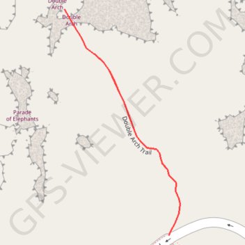
Name: Double Arch trail, distance, elevation, map, profile, GPS track
Start: Windows Road, Grand County, Utah, United States (38.68828 -109.53838)
End: Windows Road, Grand County, Utah, United States (38.68828 -109.53838)
Coordinates: 38.68828 -109.54041 38.69171 -109.53817
Topography: Grand County topographic map, elevation, terrain
Make a donation
Gear up for your next adventure:
As an Amazon Associate, this site earns from qualifying purchases at no extra cost to you.
Other hiking, mountain biking, running and outdoor activity trails
Click on a trail to view its statistics, map and profile.
Double Arch Trail in Arches National Park
United States > Utah > Grand County
The Double Arch Trail in Arches National Park offers a brief yet rewarding journey to one of the park's most iconic formations. The path meanders through a desert landscape adorned with red sandstone formations, leading to the impressive Double Arch, where two massive arches converge. The area beneath the…
Distance: 0.5 mi • Elevation gain: 121 ft • Maximum elevation: 5,249 ft