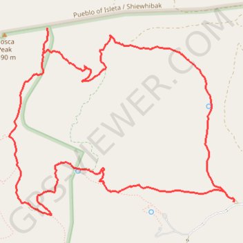
Mosca Peak Loop Trail
Wilderness hike
- Distance: 7.3 mi
- Elevation gain: 1,516 ft
- Maximum elevation: 8,832 ft
- Elevation loss: 1,516 ft
- Minimum elevation: 7,428 ft
- Moving time: 3 h 3 m
- Moving speed: 2.4 mph
- Maximum speed: 4.1 mph
- Total time: 3 h 37 m
- Global speed: 2.0 mph
Interactive trail map
Trail profile
- Distance: 7.3 mi
- Elevation gain: 1,516 ft
- Maximum elevation: 8,832 ft
- Elevation loss: 1,516 ft
- Minimum elevation: 7,428 ft
- Moving time: 3 h 3 m
- Moving speed: 2.4 mph
- Maximum speed: 4.1 mph
- Total time: 3 h 37 m
- Global speed: 2.0 mph
About this trail
Name: Mosca Peak Loop Trail trail, distance, elevation, map, profile, GPS track
Start: Albuquerque Trailhead Parking, Torrance County, New Mexico, United States (34.79360 -106.37271)
End: Albuquerque Trailhead Parking, Torrance County, New Mexico, United States (34.79359 -106.37273)
Coordinates: 34.79209 -106.40193 34.81222 -106.37270
Topography: Torrance County topographic map, elevation, terrain