Make a donation
Gear up for your next adventure:
As an Amazon Associate, this site earns from qualifying purchases at no extra cost to you.
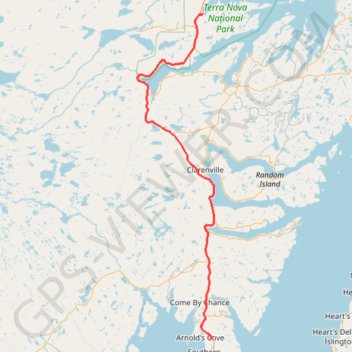
Mallorytown - Arnold's Cove
#Bike #Mallorytown #ArnoldsCove #Newfoundland
- Distance: 73.7 mi
- Elevation gain: 3,878 ft
- Maximum elevation: 489 ft
- Elevation loss: 3,842 ft
- Minimum elevation: 26 ft
Interactive trail map
Make a donation
Gear up for your next adventure:
As an Amazon Associate, this site earns from qualifying purchases at no extra cost to you.
Trail profile
- Distance: 73.7 mi
- Elevation gain: 3,878 ft
- Maximum elevation: 489 ft
- Elevation loss: 3,842 ft
- Minimum elevation: 26 ft
Make a donation
Gear up for your next adventure:
As an Amazon Associate, this site earns from qualifying purchases at no extra cost to you.
About this trail
Name: Mallorytown - Arnold's Cove trail, distance, elevation, map, profile, GPS track
Start: Newfoundland, Newfoundland and Labrador, Canada (48.54387 -53.97440)
Coordinates: 47.75619 -54.20892 48.54387 -53.93189
Make a donation
Gear up for your next adventure:
As an Amazon Associate, this site earns from qualifying purchases at no extra cost to you.
Other hiking, mountain biking, running and outdoor activity trails
Click on a trail to view its statistics, map and profile.
Arnold's Cove - Whitbourne
Canada > Newfoundland and Labrador
#Bike #ArnoldsCove #Whitbourne #Newfoundland
Distance: 31.4 mi • Elevation gain: 2,359 ft • Maximum elevation: 653 ft