Make a donation
Gear up for your next adventure:
As an Amazon Associate, this site earns from qualifying purchases at no extra cost to you.
New
- Distance: 3.7 mi
- Elevation gain: 243 ft
- Maximum elevation: 167 ft
- Elevation loss: 292 ft
- Minimum elevation: 36 ft
Interactive trail map
Make a donation
Gear up for your next adventure:
As an Amazon Associate, this site earns from qualifying purchases at no extra cost to you.
Trail profile
- Distance: 3.7 mi
- Elevation gain: 243 ft
- Maximum elevation: 167 ft
- Elevation loss: 292 ft
- Minimum elevation: 36 ft
Make a donation
Gear up for your next adventure:
As an Amazon Associate, this site earns from qualifying purchases at no extra cost to you.
About this trail
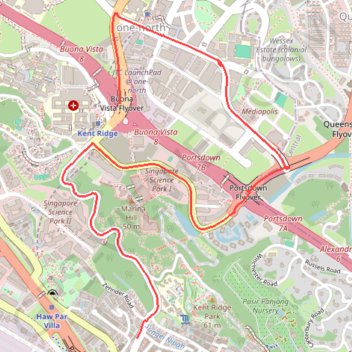
Name: New trail, distance, elevation, map, profile, GPS track
End: 21, South Buona Vista Road, Queenstown, Southwest, Singapore, 117526, Singapore (1.28088 103.78676)
Coordinates: 1.28088 103.78243 1.29956 103.79548
Make a donation
Gear up for your next adventure:
As an Amazon Associate, this site earns from qualifying purchases at no extra cost to you.
Other hiking, mountain biking, running and outdoor activity trails
Click on a trail to view its statistics, map and profile.
The Green Corridor - Singapore
Distance: 13.8 mi • Elevation gain: 548 ft • Maximum elevation: 144 ft
Rail Corridor
Distance: 5.4 mi • Elevation gain: 364 ft • Maximum elevation: 174 ft
Directions from Duck Tour Ramp to Marina Boulevard, Singapore
Distance: 65.5 mi • Elevation gain: 2,664 ft • Maximum elevation: 167 ft