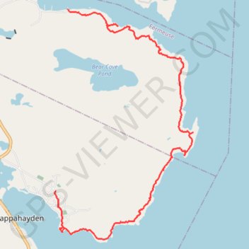
East Coast Trail - Bear Cove Point Path
#Hiking #Newfoundland #Atlantic
- Distance: 8.0 mi
- Elevation gain: 1,404 ft
- Maximum elevation: 207 ft
- Elevation loss: 1,329 ft
- Minimum elevation: 0 ft
Interactive trail map
Trail profile
- Distance: 8.0 mi
- Elevation gain: 1,404 ft
- Maximum elevation: 207 ft
- Elevation loss: 1,329 ft
- Minimum elevation: 0 ft
About this trail
Name: East Coast Trail - Bear Cove Point Path trail, distance, elevation, map, profile, GPS track
Start: Bear Cove Point Path, Fermeuse, Newfoundland, Newfoundland and Labrador, Canada (46.96499 -52.93004)
Coordinates: 46.91882 -52.93374 46.96499 -52.89292