Thank you for supporting this site ❤️
Make a donation
Make a donation
Gear up for your next adventure:
As an Amazon Associate, this site earns from qualifying purchases at no extra cost to you.
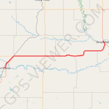
Irricana - Drumheller
- Distance: 46.6 mi
- Elevation gain: 1,030 ft
- Maximum elevation: 3,091 ft
- Elevation loss: 1,841 ft
- Minimum elevation: 2,244 ft
Interactive trail map
Thank you for supporting this site ❤️
Make a donation
Make a donation
Gear up for your next adventure:
As an Amazon Associate, this site earns from qualifying purchases at no extra cost to you.
Trail profile
- Distance: 46.6 mi
- Elevation gain: 1,030 ft
- Maximum elevation: 3,091 ft
- Elevation loss: 1,841 ft
- Minimum elevation: 2,244 ft
Thank you for supporting this site ❤️
Make a donation
Make a donation
Gear up for your next adventure:
As an Amazon Associate, this site earns from qualifying purchases at no extra cost to you.
About this trail
Name: Irricana - Drumheller trail, distance, elevation, map, profile, GPS track
Start: 300, 1st Street, Town of Irricana, Alberta, T0M 1B0, Canada (51.32325 -113.60644)
End: Willow Avenue, North Drumheller, Drumheller, Alberta, T0J 0Y3, Canada (51.46854 -112.71473)
Coordinates: 51.32129 -113.60644 51.47001 -112.70057
Thank you for supporting this site ❤️
Make a donation
Make a donation
Gear up for your next adventure:
As an Amazon Associate, this site earns from qualifying purchases at no extra cost to you.
Other hiking, mountain biking, running and outdoor activity trails
Click on a trail to view its statistics, map and profile.