Bat Sheva, Shlomo and Rodad
בת שבע והר שלמה: מסלול באלף של אילת וסכין יותם
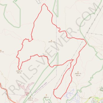
- Distance: 12.3 mi
- Elevation gain: 2,720 ft
- Maximum elevation: 2,224 ft
- Elevation loss: 2,720 ft
- Minimum elevation: 568 ft
- Moving time: 6 h 15 m
- Moving speed: 2.0 mph
- Maximum speed: 2.6 mph
- Total time: 6 h 15 m
- Global speed: 2.0 mph
Interactive trail map
Trail profile
- Distance: 12.3 mi
- Elevation gain: 2,720 ft
- Maximum elevation: 2,224 ft
- Elevation loss: 2,720 ft
- Minimum elevation: 568 ft
- Moving time: 6 h 15 m
- Moving speed: 2.0 mph
- Maximum speed: 2.6 mph
- Total time: 6 h 15 m
- Global speed: 2.0 mph
About this trail
Name: Bat Sheva, Shlomo and Rodad trail, distance, elevation, map, profile, GPS track
Start: Nahal Netafim, Eilat, Beersheba Subdistrict, South District, 8804625, Israel (29.57969 34.92976)
End: Nahal Netafim, Eilat, Beersheba Subdistrict, South District, 8804625, Israel (29.57969 34.92976)
Coordinates: 29.56557 34.89821 29.61217 34.93768
Other hiking, mountain biking, running and outdoor activity trails
Click on a trail to view its statistics, map and profile.
Eilat - Tzfahot - Yoash
Israel > South District > Eilat
הר צפחות ומצוקי גשרון: מעלות, מצוק, נחל, קניון ואספלט – המסלול הזה נותן הכל
Distance: 13.7 mi • Elevation gain: 3,107 ft • Maximum elevation: 1,936 ft
Mount Yehoram to Beer Ora
Israel > South District > Hevel Eilot Regional Council
הר יהורם לבאר אורה: קו ארוך וטכני בין הרי אילת
Distance: 17.7 mi • Elevation gain: 3,202 ft • Maximum elevation: 2,218 ft