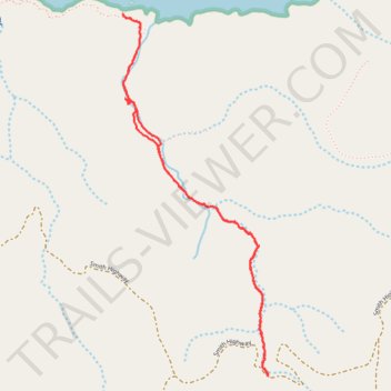
Lobo Canyon Trail
- Distance: 3.1 mi
- Elevation gain: 522 ft
- Maximum elevation: 322 ft
- Elevation loss: 515 ft
- Minimum elevation: 10 ft
- Moving time: 1 h 43 m
- Moving speed: 1.8 mph
- Maximum speed: 3.5 mph
- Total time: 2 h 49 m
- Global speed: 1.1 mph
Interactive trail map
Trail profile
- Distance: 3.1 mi
- Elevation gain: 522 ft
- Maximum elevation: 322 ft
- Elevation loss: 515 ft
- Minimum elevation: 10 ft
- Moving time: 1 h 43 m
- Moving speed: 1.8 mph
- Maximum speed: 3.5 mph
- Total time: 2 h 49 m
- Global speed: 1.1 mph
About this trail
Name: Lobo Canyon Trail trail, distance, elevation, map, profile, GPS track
Start: Lobo Canyon Trail, Santa Barbara County, California, United States (34.00326 -120.09108)
End: Smith Highway, Santa Barbara County, California, United States (34.00313 -120.09105)
Coordinates: 34.00313 -120.09920 34.01988 -120.09105
Topography: Santa Barbara County topographic map, elevation, terrain