Make a donation
Gear up for your next adventure:
As an Amazon Associate, this site earns from qualifying purchases at no extra cost to you.
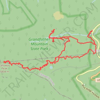
Calloway Peak Hike
- Distance: 10.3 mi
- Elevation gain: 2,470 ft
- Maximum elevation: 5,863 ft
- Elevation loss: 2,464 ft
- Minimum elevation: 3,927 ft
- Moving time: 3 h 57 m
- Moving speed: 2.6 mph
- Maximum speed: 16.9 mph
- Total time: 4 h 52 m
- Global speed: 2.1 mph
Interactive trail map
Make a donation
Gear up for your next adventure:
As an Amazon Associate, this site earns from qualifying purchases at no extra cost to you.
Trail profile
- Distance: 10.3 mi
- Elevation gain: 2,470 ft
- Maximum elevation: 5,863 ft
- Elevation loss: 2,464 ft
- Minimum elevation: 3,927 ft
- Moving time: 3 h 57 m
- Moving speed: 2.6 mph
- Maximum speed: 16.9 mph
- Total time: 4 h 52 m
- Global speed: 2.1 mph
Make a donation
Gear up for your next adventure:
As an Amazon Associate, this site earns from qualifying purchases at no extra cost to you.
About this trail
Name: Calloway Peak Hike trail, distance, elevation, map, profile, GPS track
Start: Boone Fork Parking Area, Watauga County, North Carolina, United States (36.11979 -81.78158)
End: Boone Fork Parking Area, Watauga County, North Carolina, United States (36.11998 -81.78160)
Coordinates: 36.10938 -81.81050 36.12021 -81.78025
Topography: Watauga County topographic map, elevation, terrain
Make a donation
Gear up for your next adventure:
As an Amazon Associate, this site earns from qualifying purchases at no extra cost to you.
Other hiking, mountain biking, running and outdoor activity trails
Click on a trail to view its statistics, map and profile.
Calloway Peak loop via Nuwati Trail, Storyteller Rock, Cragway Trail, Top Crag View, Flat Rock View and Daniel Boone Scout Trail in Grandfather Mountain State Park
United States > North Carolina > Watauga County
Distance: 8.6 mi • Elevation gain: 2,372 ft • Maximum elevation: 5,860 ft