Thank you for supporting this site ❤️
Make a donation
Make a donation
Gear up for your next adventure:
As an Amazon Associate, this site earns from qualifying purchases at no extra cost to you.
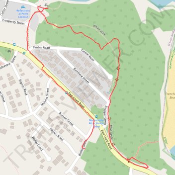
Whale Walk
- Distance: 1.3 mi
- Elevation gain: 131 ft
- Maximum elevation: 164 ft
- Elevation loss: 161 ft
- Minimum elevation: 49 ft
- Moving time: 37 m 6 s
- Moving speed: 2.0 mph
- Maximum speed: 4.1 mph
- Total time: 50 m 7 s
- Global speed: 1.5 mph
Interactive trail map
Thank you for supporting this site ❤️
Make a donation
Make a donation
Gear up for your next adventure:
As an Amazon Associate, this site earns from qualifying purchases at no extra cost to you.
Trail profile
- Distance: 1.3 mi
- Elevation gain: 131 ft
- Maximum elevation: 164 ft
- Elevation loss: 161 ft
- Minimum elevation: 49 ft
- Moving time: 37 m 6 s
- Moving speed: 2.0 mph
- Maximum speed: 4.1 mph
- Total time: 50 m 7 s
- Global speed: 1.5 mph
Thank you for supporting this site ❤️
Make a donation
Make a donation
Gear up for your next adventure:
As an Amazon Associate, this site earns from qualifying purchases at no extra cost to you.
About this trail
Name: Whale Walk trail, distance, elevation, map, profile, GPS track
Start: Whale Track, Point Lookout, Greater Brisbane, Queensland, 4183, Australia (-27.43108 153.54117)
End: Bimba Street, Point Lookout, Greater Brisbane, Queensland, 4183, Australia (-27.43074 153.53946)
Coordinates: -27.43145 153.53705 -27.42553 153.54204
Thank you for supporting this site ❤️
Make a donation
Make a donation
Gear up for your next adventure:
As an Amazon Associate, this site earns from qualifying purchases at no extra cost to you.