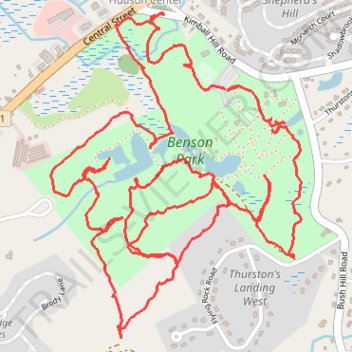
Woodland trails around Benson Park, Hudson, NH
- Distance: 5.3 mi
- Elevation gain: 404 ft
- Maximum elevation: 318 ft
- Elevation loss: 417 ft
- Minimum elevation: 164 ft
- Moving time: 1 h 52 m
- Moving speed: 2.8 mph
- Maximum speed: 24.3 mph
- Total time: 1 h 59 m
- Global speed: 2.7 mph
Interactive trail map
Trail profile
- Distance: 5.3 mi
- Elevation gain: 404 ft
- Maximum elevation: 318 ft
- Elevation loss: 417 ft
- Minimum elevation: 164 ft
- Moving time: 1 h 52 m
- Moving speed: 2.8 mph
- Maximum speed: 24.3 mph
- Total time: 1 h 59 m
- Global speed: 2.7 mph
About this trail
Name: Woodland trails around Benson Park, Hudson, NH trail, distance, elevation, map, profile, GPS track
Coordinates: 42.76048 -71.41214 42.77129 -71.40080
Topography: Hillsborough County topographic map, elevation, terrain