Thank you for supporting this site ❤️
Make a donation
Make a donation
Gear up for your next adventure:
As an Amazon Associate, this site earns from qualifying purchases at no extra cost to you.
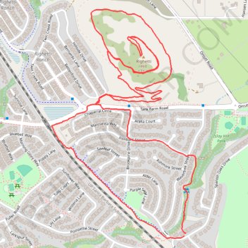
Righetti Hill Hike
- Distance: 3.5 mi
- Elevation gain: 417 ft
- Maximum elevation: 545 ft
- Elevation loss: 417 ft
- Minimum elevation: 210 ft
- Moving time: 1 h 17 m
- Moving speed: 2.7 mph
- Maximum speed: 4.2 mph
- Total time: 1 h 38 m
- Global speed: 2.1 mph
Interactive trail map
Thank you for supporting this site ❤️
Make a donation
Make a donation
Gear up for your next adventure:
As an Amazon Associate, this site earns from qualifying purchases at no extra cost to you.
Trail profile
- Distance: 3.5 mi
- Elevation gain: 417 ft
- Maximum elevation: 545 ft
- Elevation loss: 417 ft
- Minimum elevation: 210 ft
- Moving time: 1 h 17 m
- Moving speed: 2.7 mph
- Maximum speed: 4.2 mph
- Total time: 1 h 38 m
- Global speed: 2.1 mph
Thank you for supporting this site ❤️
Make a donation
Make a donation
Gear up for your next adventure:
As an Amazon Associate, this site earns from qualifying purchases at no extra cost to you.
About this trail
Name: Righetti Hill Hike trail, distance, elevation, map, profile, GPS track
Coordinates: 35.24469 -120.63476 35.25441 -120.62727
Topography: San Luis Obispo topographic map, elevation, terrain
Thank you for supporting this site ❤️
Make a donation
Make a donation
Gear up for your next adventure:
As an Amazon Associate, this site earns from qualifying purchases at no extra cost to you.