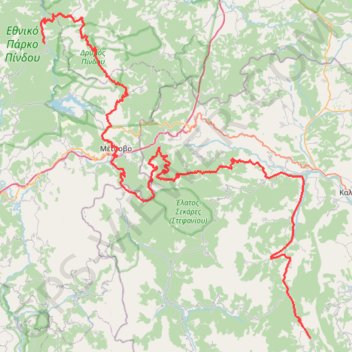
ΕΛΑΤΗ-ΚΑΛΟΜΟΙΡΑ-ΒΑΛΙΑ ΚΑΛΝΤΑ- ΒΟΒΟΥΣΑ
- Distance: 114.8 mi
- Elevation gain: 22,431 ft
- Maximum elevation: 6,063 ft
- Elevation loss: 22,093 ft
- Minimum elevation: 922 ft
Interactive trail map
Trail profile
- Distance: 114.8 mi
- Elevation gain: 22,431 ft
- Maximum elevation: 6,063 ft
- Elevation loss: 22,093 ft
- Minimum elevation: 922 ft
About this trail
Name: ΕΛΑΤΗ-ΚΑΛΟΜΟΙΡΑ-ΒΑΛΙΑ ΚΑΛΝΤΑ- ΒΟΒΟΥΣΑ trail, distance, elevation, map, profile, GPS track
Coordinates: 39.50083 21.04705 39.95753 21.53995
Other hiking, mountain biking, running and outdoor activity trails
Click on a trail to view its statistics, map and profile.
ELATI-ANTHIRO-MONH SPHLIAS-DRAKOTRYPA-ELATI
Greece > Thessaly and Central Greece > Trikala Regional Unit > Ελάτη > Λιπιότα
Distance: 100.0 mi • Elevation gain: 24,606 ft • Maximum elevation: 5,738 ft