Make a donation
Gear up for your next adventure:
As an Amazon Associate, this site earns from qualifying purchases at no extra cost to you.
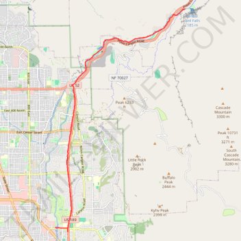
Ride up to Bridal Veil Falls
- Distance: 14.9 mi
- Elevation gain: 827 ft
- Maximum elevation: 5,138 ft
- Elevation loss: 801 ft
- Minimum elevation: 4,633 ft
Interactive trail map
Make a donation
Gear up for your next adventure:
As an Amazon Associate, this site earns from qualifying purchases at no extra cost to you.
Trail profile
- Distance: 14.9 mi
- Elevation gain: 827 ft
- Maximum elevation: 5,138 ft
- Elevation loss: 801 ft
- Minimum elevation: 4,633 ft
Make a donation
Gear up for your next adventure:
As an Amazon Associate, this site earns from qualifying purchases at no extra cost to you.
About this trail
Name: Ride up to Bridal Veil Falls trail, distance, elevation, map, profile, GPS track
Coordinates: 40.26216 -111.66434 40.33966 -111.60520
Topography: Provo topographic map, elevation, terrain
Make a donation
Gear up for your next adventure:
As an Amazon Associate, this site earns from qualifying purchases at no extra cost to you.
Other hiking, mountain biking, running and outdoor activity trails
Click on a trail to view its statistics, map and profile.
Right up to the Linden Temple and by Utah Lake
United States > Utah > Utah County > Provo > Pleasant View
Bonk ride to Lindon and by Utah Lake lake, lindon, utah, bike, paved
Distance: 23.0 mi • Elevation gain: 732 ft • Maximum elevation: 4,879 ft