Lakeshore exploration
- Distance: 18.1 mi
- Elevation gain: 89 ft
- Maximum elevation: 4,229 ft
- Elevation loss: 89 ft
- Minimum elevation: 4,206 ft
- Moving time: 1 h 55 m
- Moving speed: 9.4 mph
- Maximum speed: 20.7 mph
- Total time: 2 h 17 m
- Global speed: 7.9 mph
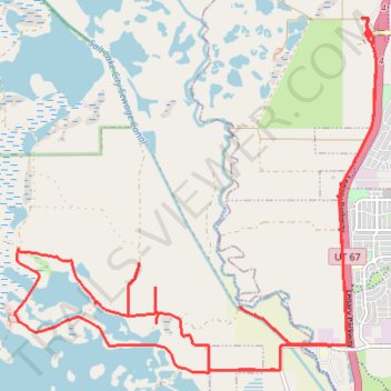
Interactive trail map
Trail profile
- Distance: 18.1 mi
- Elevation gain: 89 ft
- Maximum elevation: 4,229 ft
- Elevation loss: 89 ft
- Minimum elevation: 4,206 ft
- Moving time: 1 h 55 m
- Moving speed: 9.4 mph
- Maximum speed: 20.7 mph
- Total time: 2 h 17 m
- Global speed: 7.9 mph
About this trail
Name: Lakeshore exploration trail, distance, elevation, map, profile, GPS track
Start: Legacy Parkway Trail, Davis County, Utah, 84087, United States (40.88376 -111.93941)
End: Legacy Parkway Trail, Davis County, Utah, 84087, United States (40.88369 -111.93967)
Coordinates: 40.83822 -112.00226 40.88579 -111.93807
Topography: Davis County topographic map, elevation, terrain
Other hiking, mountain biking, running and outdoor activity trails
Click on a trail to view its statistics, map and profile.
Bike Ride from Salt Lake City to Woods Cross via Jordan River Parkway
United States > Utah > Salt Lake County > Salt Lake City
Distance: 14.2 mi • Elevation gain: 144 ft • Maximum elevation: 4,314 ft