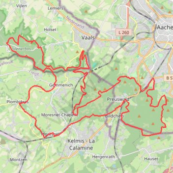
3-landen
- Distance: 32.0 mi
- Elevation gain: 3,763 ft
- Maximum elevation: 1,135 ft
- Elevation loss: 3,763 ft
- Minimum elevation: 486 ft
- Moving time: 3 h 47 m
- Moving speed: 8.4 mph
- Maximum speed: 35.7 mph
- Total time: 3 h 47 m
- Global speed: 8.4 mph
Interactive trail map
Trail profile
- Distance: 32.0 mi
- Elevation gain: 3,763 ft
- Maximum elevation: 1,135 ft
- Elevation loss: 3,763 ft
- Minimum elevation: 486 ft
- Moving time: 3 h 47 m
- Moving speed: 8.4 mph
- Maximum speed: 35.7 mph
- Total time: 3 h 47 m
- Global speed: 8.4 mph
About this trail
Name: 3-landen trail, distance, elevation, map, profile, GPS track
Coordinates: 50.71893 5.95200 50.77209 6.08359
Other hiking, mountain biking, running and outdoor activity trails
Click on a trail to view its statistics, map and profile.
GR005_Parcours-principal_2021-05-06
Netherlands > Limburg > Maastricht
GR005_Parcours-principal_2021-05-06
Distance: 205.8 mi • Elevation gain: 29,472 ft • Maximum elevation: 1,877 ft
240 KM 2022
Netherlands > Limburg > Valkenburg
Distance: 150.2 mi • Elevation gain: 9,311 ft • Maximum elevation: 1,076 ft
Riethoven naar Oostenrijk
Netherlands > North Brabant > Riethoven > Eind
Distance: 573.0 mi • Elevation gain: 44,715 ft • Maximum elevation: 6,224 ft
Eurovelo 15 - Strasbourg Rotterdam
France > Grand Est > Bas-Rhin > Strasbourg
Distance: 554.1 mi • Elevation gain: 6,903 ft • Maximum elevation: 479 ft
TET NL Süd Marc
Netherlands > Limburg > Susteren
Distance: 95.8 mi • Elevation gain: 4,209 ft • Maximum elevation: 1,089 ft
Mh2d 2024 - MTB Zaterdag - 070 km
Netherlands > Limburg > Sint Geertruid > Moerslag
Distance: 46.8 mi • Elevation gain: 4,255 ft • Maximum elevation: 1,129 ft