Gravel Bike City Square Park
- Distance: 1.4 mi
- Elevation gain: 26 ft
- Maximum elevation: 39 ft
- Elevation loss: 52 ft
- Minimum elevation: 13 ft
- Moving time: 15 m 3 s
- Moving speed: 5.5 mph
- Maximum speed: 9.3 mph
- Total time: 15 m 3 s
- Global speed: 5.5 mph
Interactive trail map
Trail profile
- Distance: 1.4 mi
- Elevation gain: 26 ft
- Maximum elevation: 39 ft
- Elevation loss: 52 ft
- Minimum elevation: 13 ft
- Moving time: 15 m 3 s
- Moving speed: 5.5 mph
- Maximum speed: 9.3 mph
- Total time: 15 m 3 s
- Global speed: 5.5 mph
About this trail
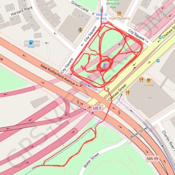
Name: Gravel Bike City Square Park trail, distance, elevation, map, profile, GPS track
End: US 1, Charlestown, Boston, Suffolk County, Massachusetts, 02222, United States (42.37027 -71.06316)
Coordinates: 42.37027 -71.06316 42.37231 -71.06128
Topography: Boston topographic map, elevation, terrain
Other hiking, mountain biking, running and outdoor activity trails
Click on a trail to view its statistics, map and profile.
Boston's Freedom Trail
United States > Massachusetts > Suffolk County > Boston
Walking Boston's Freedom Trail offers a seamless journey through America’s Revolutionary history, with a lively path marked by historic buildings and memorials, from the lush Boston Common to the monumental Bunker Hill. Each stop, such as the Old South Meeting House and Faneuil Hall, is packed with stories…
Distance: 2.4 mi • Elevation gain: 207 ft • Maximum elevation: 125 ft
Nahant and Northern Strand Trail
United States > Massachusetts > Suffolk County > Boston
Distance: 43.7 mi • Elevation gain: 1,273 ft • Maximum elevation: 75 ft